
Fayum (2003) Fayum (Egypt) - 3462 - 2003-12-01. [Practice/process]
![[img]](http://dap.ub.rug.nl/11402/1/3462.jpg)
|
Image
3462.jpg - Submitted Version Download (1MB) | Preview |

| Item Type: | Practice/process |
|---|---|
| Documents: |
Image
3462.jpg - Submitted Version Other (Thumbnails conversion from image to thumbnail_lightbox) lightbox.jpg Other (Thumbnails conversion from image to thumbnail_preview) preview.jpg Other (Thumbnails conversion from image to thumbnail_medium) medium.jpg Other (Thumbnails conversion from image to thumbnail_small) small.jpg |
| Title: | Fayum (Egypt) - 3462 - 2003-12-01 |
| Photo number: | 3462 |
| Photo authenticity: pose: | Unknown |
| Photo authenticity: activity: | Unknown |
| Photo authenticity: setting: | Authentic |
| Date: | 1 December 2003 |
| Date: accuracy: | Only year and month are known |
| Location: site name: | Fayum |
| Location: country: | Egypt |
| GPS-north: degrees: | 29 |
| GPS-north: minutes: | 25 |
| GPS-north: seconds: | 0 |
| GPS-east: degrees: | 30 |
| GPS-east: minutes: | 54 |
| GPS-east: seconds: | 0 |
| GPS accuracy: | Unknown |
| Family number: | 0 |
| Genus number: | 0 |
| Process: level 1: | Working the fields |
| Process: level 2: | ["eprint_fieldopt_process_level_2_water_manegement" not defined] |
| Process: level 3: | Irrigation |
| People: gender: | Unknown |
| People: age: | Unknown |
| Object: level 1: | Utensil |
| Object: level 2: | Irrigation channel |
| Environment: level 1: | Field |
| Photographer: | Cappers, R.T.J. |
| Figure: | 151 |
| GPS North WGS84: | +29.41666667 |
| GPS East WGS84: | +30.9 |
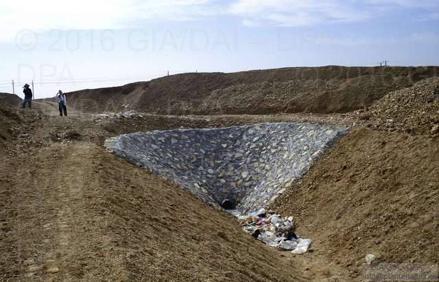
| Caption: | Large irrigation canal used as the main artery for the supply of Nile River water to transform the desert into an agricultural landscape. This large canal dissects the outcrop with the Kom K-pits. |
| Depositing User: | Unnamed user with email ub-repos@rug.nl |
| Date Deposited: | 26 Sep 2017 12:38 |
| Last Modified: | 26 Sep 2017 12:38 |
| URI: | http://dap.ub.rug.nl/id/eprint/11402 |
Actions (login required)
 |
View Item |
