
Kwera Kani (2014) Kwera Kani (Iraq) - 6242 - 2014-06-10. [Practice/process]
![[img]](http://dap.ub.rug.nl/11799/1/6242.jpg)
|
Image
6242.jpg - Submitted Version Download (1MB) | Preview |

| Item Type: | Practice/process |
|---|---|
| Documents: |
Other (Thumbnails conversion from image to thumbnail_small)
small.jpg Other (Thumbnails conversion from image to thumbnail_medium) medium.jpg Other (Thumbnails conversion from image to thumbnail_preview) preview.jpg Other (Thumbnails conversion from image to thumbnail_lightbox) lightbox.jpg Image 6242.jpg - Submitted Version |
| Title: | Kwera Kani (Iraq) - 6242 - 2014-06-10 |
| Photo number: | 6242 |
| Photo authenticity: pose: | Unknown |
| Photo authenticity: activity: | Unknown |
| Photo authenticity: setting: | Unknown |
| Date: | 10 June 2014 |
| Date: accuracy: | Year, month and day are known |
| Location: site name: | Kwera Kani |
| Location: country: | Iraq |
| GPS-north: degrees: | 35 |
| GPS-north: minutes: | 59 |
| GPS-north: seconds: | 21 |
| GPS-east: degrees: | 45 |
| GPS-east: minutes: | 2 |
| GPS-east: seconds: | 43 |
| GPS accuracy: | Unknown |
| Family number: | 0 |
| Genus number: | 0 |
| Process: level 1: | Working the fields |
| Process: level 2: | ["eprint_fieldopt_process_level_2_water_manegement" not defined] |
| Process: level 3: | Flooding |
| People: gender: | Unknown |
| People: age: | Unknown |
| Environment: level 1: | Field |
| Photographer: | Cappers, R.T.J. |
| Figure: | 109 |
| GPS North WGS84: | +35.98916667 |
| GPS East WGS84: | +45.04527778 |
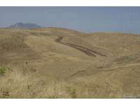
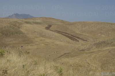
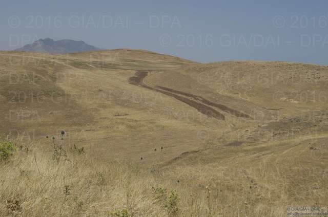
| Caption: | Small strips of arable land fringe a stream. Natural flooding makes it possible to cultivate parcels of land that that have appropriate elevation and slope in relation to the watercourse and are flooded with water from the stream. |
| Depositing User: | Unnamed user with email ub-repos@rug.nl |
| Date Deposited: | 26 Sep 2017 12:40 |
| Last Modified: | 26 Sep 2017 12:40 |
| URI: | http://dap.ub.rug.nl/id/eprint/11799 |
Actions (login required)
 |
View Item |
